
Page 480 - Le Operazioni Interforze e Multinazionali nella Storia Militare - ACTA Tomo II
P. 480
1120 XXXIX Congresso della CommIssIone InternazIonale dI storIa mIlItare • CIHm
humanitarian and caring Red Army:
„The supreme command of the Red
Army intended to preserve the Ger-
man Nation and to blow the fascist
beast in its cave [...]“ . To support
29
this claim a three-dimensional mo-
dell of Berlin was exhibted. Follo-
wing the guide Marshall Zhukov
ordered it’s fabrication on the eve of
the storming; it shows all the 600‘000
houses which weren’t destroyed prior
to the start of the Berlin-Operation. 30
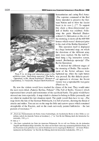
This operation itself is displayed
in a huge horizontal map, on which
the directions of the different army
units were marked. On the wall be-
hind hung a big interactive screen,
named „Berlinskaja operacija“ (The
Berlin Operation)
It showed the different stages of
the storming of Berlin. The encircle-
ment of the Soviet advance were
Photo 9: (n. d.) Map and interactive screen in the lightened up, when the right button
exhibition room: „Berlinskaja operacija“ (The Berlin- was pressed. By this didactic-practi-
Operation), in the „Muzej Kapituljacii“ (Museum of cal approach is obvious: the Soviet
Capitulation), in: Fotoarchiv, Museum Berlin-Karlshorst.
victory was a reproducible war-game
(Photo no. 9).
By now the visitors would have reached the climax of the tour: They would enter
the next room titled „Padenie Berlina. Pobeda!“ (The Fall of Berlin, Victory!) which
represented hero awards and testimonies of the sacrificial battle. The guide would have
stressed one item especially: A map which is claimed to belong to Hitler personally and
on which he marked his last situation report. The guide would then have to say: „The
map shows the fate of the German Wehrmacht, it is full of arrows, showing the threat of
attacks and strikes. You can see on the map the little and narrow spaces which remained
strongholds of the Fascists, and on the roads nervously painted halfcircles – the last
pockets of resistance.“ 31
29 „Doch das Oberkommando der Roten Armee beabsichtigte, die faschistische Bestie in ihrer Höhle zu ver-
nichten, jedoch die deutsche Nation zu bewahren [...].“ in: Text für die Führung durch die historische Ge-
denkstätte, 1985, p. 6.
30 ibid. p. 7.
31 „Die Karte verdeutlicht das Ende der deutschen Wehrmacht. Sie ist voll von Pfeilen, die die drohenden
Angriffe und Flankenschläge darstellen. Sie sehen auf der Karte einen eng zusammengedrückten Raum, der
den Faschisten noch geblieben war, und im Straßennetz nervös eingetragene Halbkreise – die letzten Widers-
tandsnester der Faschisten.“ in: Text für die Führung durch die historische Gedenkstätte, 1985, p. 8.